How AI and Satellites are Working Together to Detail Permafrost Thaw
Andrei Mihai
This article is part of an ongoing series of articles on how artificial intelligence is currently being used to make the world a better place. For previous stories, check out how AI is looking for delicious meat alternatives, how AI is helping astronomers discover new planets, and how algorithms can partner up with human intuition to make fundamental discoveries.
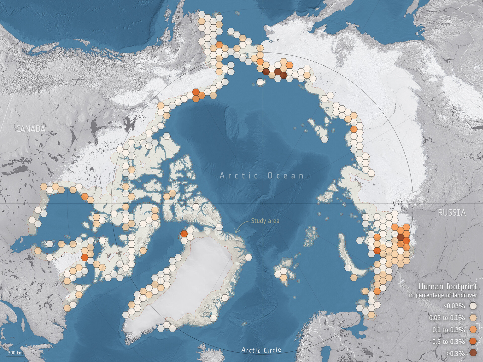
Research that uses data from the Copernicus Sentinel-1 and Sentinel-2 missions along with artificial intelligence offers a complete overview of the Arctic, identifying communities and infrastructure that will be at risk of permafrost thaw over the next 30 years. Image credits: Obu et al. (2021), Permafrost CCI/ESA
The melting of ice, snow, and permafrost is one of the many problems caused by climate change. The underlying principle is simple: the higher temperatures go up, the more frozen mass will thaw. But analyzing this in geographical detail, along with intricate feedback mechanisms and interaction with human activity, is much more difficult.
Take permafrost, for instance: Permafrost is ground that has remained continuously frozen (below 0 °C) for at least two years. Around 15% of the Northern Hemisphere’s land area (and 11% of the global land surface) is underlain by permafrost, including vast areas of Canada, Greenland, and Siberia. Permafrost also contains large amounts of decomposed biomass stored as methane, a potent greenhouse gas. This means that when it thaws, it releases more methane into the atmosphere, fueling even more climate change. It gets even more complicated when we start to consider albedo. Albedo is a measure of how much solar radiation is reflected back from the ground surface – when permafrost thaws, it becomes darker and absorbs more heat, melting more permafrost, and so on.
Luckily, nowadays we have satellites keeping track of permafrost and polar ice caps. Over the past two decades, satellites have created detailed timeline maps of the polar, arctic, and subarctic areas.
“It’s like a virtual passport to see this remote and difficult to reach part of the world,” says Chandi Witharana, assistant professor of Natural Resources and the Environment at the University of Connecticut, in a press release. “Satellite imaging helps us monitor remote landscape[s] in a detailed manner that we never had before.”
The problem is there is so much data that it is almost not humanly possible to go through it all. This is where artificial intelligence – and machine learning in particular – comes in.
The most immediate application of this approach is to study the impact of melting permafrost on human infrastructure, a task undertaken in a recent study by Annett Bartsch, a member of the European Space Agency’s Climate Change Initiative Permafrost Project. Because there is so much permafrost (especially in North America and Eurasia), there is also a lot of infrastructure built on or around permafrost. Barsch’s project used artificial intelligence applied to satellite data from the Copernicus Sentinel-1 and Sentinel-2 missions to identify communities and assets that are vulnerable to thawing permafrost. In particular, they used Keras, a deep learning API written in Python, running on the TensorFlow machine learning platform.
With this approach, the team found that, despite the risks of doing so, the overall human presence on permafrost likely to thaw has been increased by 15% in the past two decades. Overall, 55% of the infrastructure currently located on permafrost and within 100 km of the Arctic coastline is likely to be affected, which will be very challenging for local communities to address, the researchers conclude.
But this is just the beginning of how satellites and AI can help us understand what’s going on in Arctic areas. Witharana, along with Kenton McHenry from the National Center for Supercomputing Applications and Arctic researcher Anna Liljedahl of the Woodwell Climate Research Center, are working to make data about the Arctic permafrost more accessible to the world.
They have been given free access to archives of over 1 million images from the Arctic. That’s a lot of data, and traditional methods of analyzing and presenting it have proven ineffective. “That’s where we brought in AI-based deep learning methods to process and analyze this large amount of data,” Witharana said.
Their approach was inspired by facial recognition AIs. As they learned about this, the team wondered if the same approach couldn’t be used to identify permafrost ice wedges, which produce unique patterns that can be picked up by satellite data.

Crack patterns in permafrost. Image credits: Brocken Inaglory
The research team started using a neural network to detect polygons from these Arctic satellite images. To do this, they first manually annotated over 50,000 individual polygons, drawing their outlines and classifying them as either low-centered or high-centered – high-centered polygons look a bit like muffins, Liljedahl said, and they are evidence of thawing.
The team then trained their model to detect its own wedges and be able to map thawing permafrost. It wasn’t easy. Some permafrost wedges are centuries or thousands of years old, while some are newer and differently shaped. But after three years of work, they are seeing results that are accurate 80-90% of the time. They were also able to use a supercomputer (the Longhorn supercomputer) to accelerate the process.
By now, they have already mapped a whopping 1.2 billion ice-wedge polygons, and are about halfway through the data set. They also made this data accessible through the Permafrost Discovery Gateway, which other researchers can use and analyze. “Instead of having to wait 10 years to learn about something, they can learn about it right away and explore it directly through their own experience,” Liljedahl said.
By analyzing this information in different years (and different times of the year) and comparing the shape of these polygons, research teams can infer thawing trends and trajectories, monitoring how fast the landscape is changing and where these changes are most likely to happen. Somewhat similar methods are being used to study glacier and Arctic ice thawing. “This is a perfect example of how previous investments in computing infrastructure, combined with new understanding of deep learning techniques, are building a resource to help with an important issue in the Arctic,” concluded NSF Program Director Kendra McLauchlan.
The effect of thawing permafrost isn’t just local – it’s global. Having a better understanding of how and when permafrost is thawing could improve global climate models, helping climate scientists make better predictions about the evolution of global climate change. If we are to tackle climate change, it’s vital that we know what to expect – and this type of research can help us do just that.
The post How AI and Satellites are Working Together to Detail Permafrost Thaw originally appeared on the HLFF SciLogs blog.